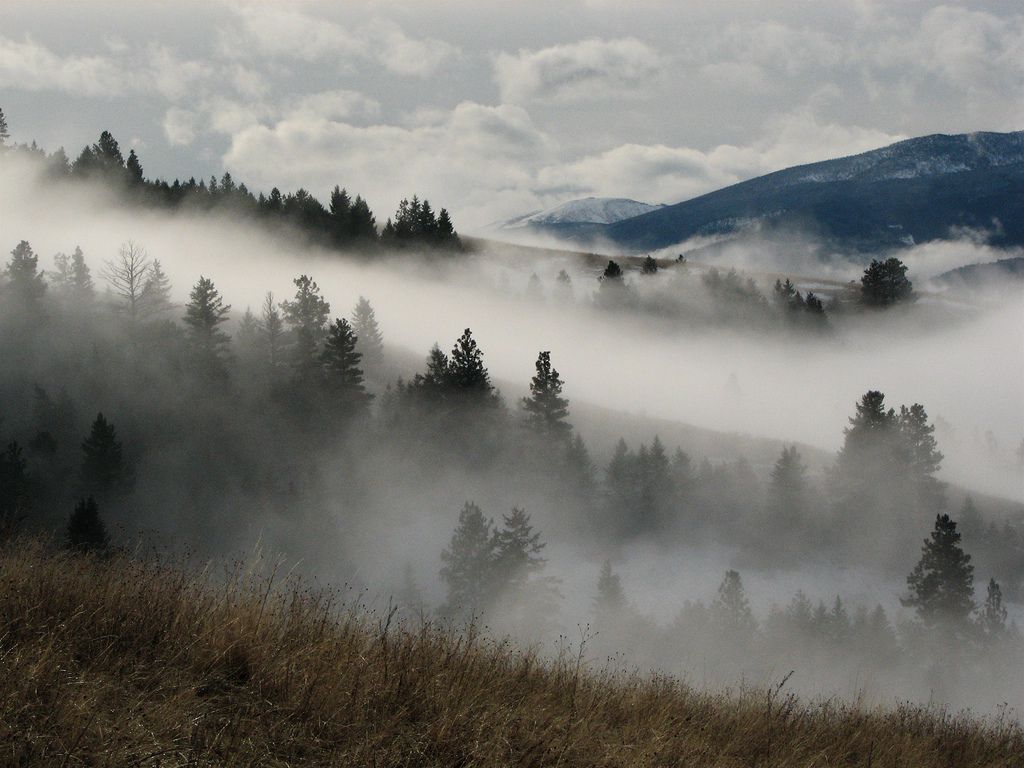
Wave clouds represent one of nature’s most spectacular atmospheric phenomena, creating mesmerizing patterns that sweep across mountain peaks like frozen ocean waves suspended in the sky.
🌄 The Science Behind Nature’s Aerial Symphony
Wave clouds form through a fascinating interaction between wind patterns and mountainous terrain. When stable air flows over mountain ranges, it creates a series of oscillating waves on the downwind side, much like water flowing over rocks in a stream. These atmospheric waves, known as lee waves or mountain waves, become visible when moisture in the air condenses at the wave crests, creating spectacular cloud formations that appear to hover motionless above the peaks.
The formation process requires specific atmospheric conditions. The air must be stable, meaning cooler air sits below warmer air, and there must be sufficient moisture at the altitude where the wave crests occur. Wind speed and direction play crucial roles, typically requiring steady winds perpendicular to the mountain range at speeds of fifteen to thirty miles per hour. When these conditions align perfectly, the result is a breathtaking display of parallel cloud bands that can stretch for hundreds of miles.
Identifying Different Types of Mountain Wave Clouds
Wave clouds manifest in several distinct forms, each with unique characteristics that reveal different atmospheric conditions. Understanding these variations helps meteorologists predict weather patterns and allows enthusiasts to appreciate the complexity of these formations.
Lenticular Clouds: The Most Iconic Formation ☁️
Lenticular clouds are perhaps the most recognizable type of wave cloud, earning their name from their lens or almond-shaped appearance. These smooth, saucer-like formations often stack in layers, creating what many observers mistake for UFOs. Pilots know these clouds as indicators of potentially severe turbulence and typically avoid flying through them. The stationary appearance of lenticular clouds is deceptive—while they seem frozen in place, air continuously flows through them, with water droplets condensing on the upwind side and evaporating on the downwind side.
Rotor Clouds and Their Turbulent Nature
Beneath the smooth lenticular clouds, rotor clouds sometimes form in areas of intense turbulence. These ragged, rotating clouds develop in the trough of the wave where air circulation creates a horizontal vortex. Rotor clouds are particularly important for aviation safety, as they mark zones of severe turbulence that can pose serious hazards to aircraft. Unlike their smooth lenticular cousins above, rotor clouds appear torn and constantly changing, reflecting the chaotic air movements within them.
Cap Clouds Crowning Mountain Summits
Cap clouds, or pileus clouds, form directly over mountain peaks when moist air is forced upward and cools to its dew point. These clouds appear to sit like hats on mountaintops, remaining stationary even in strong winds. Cap clouds often serve as the first indication that conditions are favorable for more extensive wave cloud development, acting as harbingers of the spectacular formations that may follow.
🏔️ World-Famous Locations for Wave Cloud Observation
Certain geographic locations around the globe have become legendary among cloud enthusiasts and photographers for their frequent and dramatic wave cloud displays. These sites combine ideal topography with atmospheric conditions that regularly produce stunning formations.
The Sierra Nevada Range: California’s Cloud Factory
The Sierra Nevada mountains in California stand as one of the most productive wave cloud generators in North America. The steep eastern escarpment creates powerful lee waves that produce spectacular lenticular displays, particularly during winter and spring. Mount Whitney and the surrounding peaks frequently host multi-layered lenticular stacks that can be visible from hundreds of miles away. Photographers flock to locations like Owens Valley and Mono Lake to capture these formations against the backdrop of snow-capped peaks.
New Zealand’s Southern Alps
The Southern Alps of New Zealand create some of the most impressive wave cloud systems in the Southern Hemisphere. The combination of prevailing westerly winds and the dramatic terrain produces consistent wave patterns that glider pilots have utilized to set altitude records. The town of Omarama has become an international hub for wave soaring, where pilots ride these invisible atmospheric waves to heights exceeding forty thousand feet.
Patagonian Peaks and Antarctic Peninsula
The remote mountains of Patagonia and the Antarctic Peninsula generate some of the planet’s most extreme wave cloud formations. The unobstructed wind flow across the Southern Ocean encounters these mountain barriers, creating massive wave systems. The Torres del Paine in Chile and Mount Fitz Roy in Argentina regularly display spectacular lenticular formations that photographers brave harsh conditions to document.
The Photographer’s Guide to Capturing Wave Clouds 📸
Photographing wave clouds requires patience, preparation, and understanding of both meteorology and photographic technique. These ephemeral formations demand that photographers be ready to capture them when conditions align.
Timing and Weather Prediction
Successful wave cloud photography begins with accurate weather forecasting. Monitoring upper-level wind patterns, humidity levels, and atmospheric stability helps predict when formations will occur. Many photographers use specialized meteorological tools and satellite imagery to identify developing conditions. Early morning and late afternoon typically provide the best lighting, with the golden hour illuminating the clouds with warm tones that contrast beautifully against blue skies.
Essential Equipment and Camera Settings
Wide-angle lenses capture the grand scale of wave cloud formations, while telephoto lenses isolate individual cloud details and compress perspective to emphasize layering. A sturdy tripod proves essential for long exposures during low-light conditions. Polarizing filters enhance cloud contrast against the sky, making the formations more dramatic. Camera settings should prioritize detail retention, with lower ISO values reducing noise and smaller apertures increasing depth of field to keep both foreground mountains and distant clouds sharp.
Aviation and Wave Clouds: Beauty Meets Danger ✈️
For pilots, wave clouds represent both opportunity and hazard. Understanding their implications is crucial for flight safety and, for glider pilots particularly, can enable extraordinary achievements.
Turbulence and Flight Hazards
Mountain wave turbulence ranks among the most severe atmospheric disturbances aircraft can encounter. The waves can extend dozens of miles downwind from mountain ranges and reach altitudes well above the peaks themselves. Pilots of powered aircraft typically avoid these areas when wave clouds are present, as the turbulence can stress aircraft structures and create uncomfortable or dangerous conditions for passengers and crew. The rotor zone beneath lenticular clouds poses the greatest risk, with violent updrafts and downdrafts that can exceed the climb capability of many aircraft.
Soaring to Record Heights
Glider pilots view mountain waves differently—as natural elevators to extreme altitudes. Wave soaring has enabled sailplane pilots to reach heights exceeding fifty thousand feet, higher than most commercial airliners cruise. These flights require specialized equipment including oxygen systems and pressure suits, but they demonstrate the immense power contained in these atmospheric phenomena. Wave soaring requires precise positioning and expert understanding of the wave structure, as pilots work to stay within the ascending portions of the wave system.
🌡️ Climate Patterns and Wave Cloud Formation
Wave cloud occurrence correlates strongly with larger climate patterns and seasonal variations. Understanding these connections helps explain why certain times of year produce more frequent or dramatic formations.
Seasonal Influences on Wave Activity
Winter and spring typically produce the most impressive wave cloud displays in many mountain regions. During these seasons, strong upper-level winds associated with the jet stream flow more consistently across mountain ranges. The temperature differential between air masses is also greater, creating the stable atmospheric conditions necessary for sustained wave development. Summer tends to produce less frequent wave activity due to weaker winds and less stable air masses, though exceptions occur in certain geographic locations.
El Niño and La Niña Effects
Large-scale climate oscillations influence wave cloud frequency and intensity. El Niño events shift storm tracks and wind patterns, altering the typical wave cloud season in various mountain regions. La Niña conditions can intensify westerly winds, potentially increasing wave activity in ranges aligned perpendicular to these flows. Long-term climate records show correlations between these oscillations and wave cloud occurrence, though local topography and regional weather patterns create significant variability.
Cultural Significance and Historical Observations
Throughout history, wave clouds have inspired awe and speculation in cultures living near mountain ranges. Before scientific understanding explained their formation, these phenomena sparked myths and legends.
Indigenous Interpretations and Folklore
Many indigenous peoples developed rich traditions around mountain cloud formations. Some cultures interpreted lenticular clouds as spiritual messages or omens, while others saw them as manifestations of mountain spirits. The Māori of New Zealand recognized the connection between certain cloud formations and weather changes, incorporating this knowledge into their navigation and agricultural practices. These traditional observations often contained accurate meteorological insights, recognizing patterns that modern science would later explain.
Early Scientific Documentation
Scientific interest in mountain wave phenomena accelerated during the early twentieth century as aviation developed. German glider pilots in the 1930s were among the first to systematically study and exploit mountain waves for soaring. World War II brought increased attention to the phenomenon after several mysterious aircraft incidents were attributed to severe mountain wave turbulence. Post-war research established the theoretical framework explaining wave cloud formation, though new discoveries continue to refine our understanding.
🔬 Advanced Meteorological Research and Wave Clouds
Modern meteorology continues to investigate wave clouds using sophisticated tools and techniques. This research enhances weather forecasting and deepens our understanding of atmospheric dynamics.
Satellite and Radar Observations
Current satellite technology enables meteorologists to observe wave cloud systems across entire continents simultaneously. High-resolution imagery reveals fine details of wave structure and evolution that ground-based observations cannot capture. Doppler radar systems measure wind velocities within and around wave systems, providing data about turbulence intensity and wave propagation. These observations improve aviation weather forecasts and contribute to numerical weather prediction models.
Computer Modeling of Mountain Waves
Advanced computer models simulate mountain wave formation with increasing accuracy, helping meteorologists predict when and where dramatic wave clouds will develop. These models incorporate terrain data, atmospheric soundings, and wind forecasts to calculate wave characteristics. Researchers use these simulations to study how mountains of different shapes and sizes influence wave formation, improving our ability to forecast conditions at locations lacking extensive historical observations.
Experiencing Wave Clouds: A Bucket List Adventure 🎒
For weather enthusiasts and nature lovers, witnessing spectacular wave cloud formations ranks among the most rewarding outdoor experiences. Planning a trip specifically to observe these phenomena requires research and flexibility.
Planning Your Wave Cloud Expedition
Successful wave cloud observation trips require selecting locations known for frequent formations and visiting during optimal seasons. Flexibility in scheduling allows you to adjust plans based on weather forecasts, as predicting exact conditions more than a few days in advance remains challenging. Joining online communities of cloud enthusiasts provides valuable real-time information about developing conditions and successful observation locations.
What to Bring and Safety Considerations
Mountain weather can change rapidly, so appropriate clothing and safety equipment are essential. Even when observing from valley locations, temperatures can drop quickly and wind speeds may be significant. Bringing binoculars enhances your ability to observe cloud details and structure. Always inform someone of your plans and expected return time when venturing into remote areas. Remember that the same conditions creating beautiful wave clouds often produce strong winds and turbulence that can make mountain ridges dangerous places to observe from.
The Future of Wave Cloud Study and Appreciation
As climate patterns shift and technology advances, our relationship with wave clouds continues to evolve. These formations serve as visible indicators of atmospheric processes that influence weather patterns, aviation safety, and our understanding of fluid dynamics.
Increased public interest in meteorological phenomena has created growing communities of cloud enthusiasts who share observations and photographs through social media and specialized platforms. This citizen science contributes valuable data about wave cloud occurrence and characteristics across diverse geographic locations. Educational initiatives help more people understand and appreciate these natural wonders, fostering greater environmental awareness and scientific literacy.
Research into mountain waves continues to reveal new insights about atmospheric behavior. Studies examining how climate change might alter wind patterns and atmospheric stability could affect wave cloud frequency and characteristics in various mountain regions. Understanding these changes has practical implications for aviation, renewable energy development, and weather forecasting.
🌟 The Enduring Fascination of Clouds Dancing on Mountains
Wave clouds remain one of nature’s most visually stunning atmospheric displays, combining scientific complexity with artistic beauty. Whether you’re a meteorologist analyzing their structure, a pilot respecting their power, or a photographer capturing their elegance, these formations inspire wonder and appreciation for the dynamic atmosphere surrounding our planet.
The interplay between solid earth and flowing air creates patterns that remind us of the constant motion and energy transfer occurring in our atmosphere. Mountains stand as sculptors, shaping the invisible wind into visible forms that reveal the hidden architecture of air currents and temperature gradients. Each wave cloud formation is unique, a temporary masterpiece created by specific conditions that may never align exactly the same way again.
As you gaze upon these majestic clouds dancing above mountain ranges, you witness the elegant mathematics of fluid dynamics made visible. The smooth curves of lenticular clouds, the turbulent chaos of rotor formations, and the gentle caps crowning peaks all tell stories about wind speed, moisture content, atmospheric stability, and the shape of the terrain below. They bridge the gap between the tangible mountains we can touch and the intangible atmosphere we breathe, creating a visual connection between earth and sky that has captivated human imagination for millennia.

Toni Santos is a visual storyteller and artisan whose creations celebrate the poetry of the natural world. Through his thoughtful artistic lens, Toni captures the elegance of botanical forms, transforming them into meaningful expressions of symbolism, resilience, and timeless beauty.
His journey is deeply rooted in a passion for flora and the mysteries they carry. From the shape of a petal to the curve of a vine, each design Toni brings to life reflects a deeper narrative — one of growth, transformation, and harmony with nature. Whether crafting symbolic floral jewelry, enchanted botanical illustrations, or seasonal visual studies, Toni’s work evokes the quiet magic found in Earth’s most delicate details.
With a background in handcrafted artistry and visual design, Toni blends technique with intention. His creations do more than decorate — they speak, often inspired by ancient meanings behind flowers, the cycles of the seasons, and the invisible bonds between nature and spirit.
As the creative voice behind Vizovex, Toni shares this botanical journey with the world, offering curated stories, handcrafted collections, and thoughtful articles that help others reconnect with nature’s symbolism and artistic essence.
His work is a tribute to:
The quiet power of flowers and their messages
The art of visual symbolism in everyday life
The beauty of slowing down to see what’s hidden in plain sight
Whether you’re an artist, a nature lover, or someone drawn to the deeper meanings behind the natural world, Toni welcomes you to explore a space where aesthetics meet soul — one petal, one story, one creation at a time.